Snow Day Predictor & Calculator – Find Out If School Is Likely to Close Tomorrow
Use the Snow Day Predictor for an automatic, location-based forecast, or use the Manual Snow Day Calculator to test your own weather conditions and see how they affect the chance of a school closure.
❄️ Snow Day Predictor – Get your location-based prediction
Enter your city, ZIP code, postal code, or coordinates. We’ll use the available forecast information for your location to estimate the chance of a school closure.
Which Snow Day Tool Should I Use?
Not sure whether to use the predictor or calculator? Choose based on what you want to know.
| If you want to… | Use |
|---|---|
| Know your chances for tomorrow | Snow Day Predictor |
| Get a prediction from your location | Snow Day Predictor |
| Use the current forecast | Snow Day Predictor |
| Test a specific amount of snowfall | Snow Day Calculator |
| Change temperature or wind chill yourself | Snow Day Calculator |
| Compare different storm scenarios | Snow Day Calculator |
| See how district policy affects the result | Snow Day Calculator |
| Create a “what if?” situation | Snow Day Calculator |
How Does the Snow Day Predictor Work?
The Snow Day Predictor estimates the likelihood of a school closure by looking at the weather conditions expected in your area and how those conditions can affect a typical school morning. Instead of treating snowfall as the only deciding factor, the prediction considers several winter-weather signals that can influence whether traveling to school becomes difficult or unsafe.
When you enter your location, the predictor uses the available forecast for that area and evaluates factors such as expected snowfall, precipitation type, temperature, wind chill, storm timing, and other relevant winter conditions. Your selected district policy can also influence the result.
The goal isn’t to predict the superintendent’s decision with certainty. It’s to turn a complicated weather forecast into a simple snow day probability that helps you understand how likely a cancellation may be.
What Factors Affect Your Snow Day Prediction?
❄️ Snowfall Amount
The amount of snow expected is one of the most obvious factors affecting school closures. More accumulation can make roads, parking areas, sidewalks, and school bus routes harder to clear, but the same snowfall amount does not create the same closure risk everywhere.
A few inches can be a significant disruption in an area that rarely receives snow, while districts accustomed to frequent winter storms may continue operating under considerably higher totals.
🏫 District Policy
School districts don’t all respond to winter weather in exactly the same way.
Some districts are more willing to cancel or delay school when conditions become questionable, while others may remain open under similar weather conditions. The district policy setting allows the prediction to reflect this difference rather than assuming that every school system uses the same threshold.
🌧️ Precipitation Type
Snow isn’t the only winter precipitation that can affect whether school opens.
Freezing rain, sleet, and mixed precipitation can create hazardous travel conditions even when the total snowfall is relatively low. Ice can make roads, bridges, sidewalks, and parking lots difficult to treat and may increase the likelihood of a delay or closure.
🌡️ Temperature & Wind Chill
Extreme cold can create school closure risks even when there is little or no snow.
Low temperatures and wind chill affect students waiting for buses, people walking to school, vehicle operation, and the ability of roads and sidewalks to remain safe. That’s why a snow day prediction shouldn’t depend on snowfall alone.
🕒 Storm Timing
When the weather occurs can be just as important as how much precipitation falls.
Snow or ice that develops overnight and continues into the morning commute can create a very different situation from the same amount of precipitation falling after roads have already been cleared.
The predictor therefore considers the timing of winter weather in relation to the school day rather than looking only at the final snowfall total.
If you’re interested in the methodology behind the prediction, our Snow Day Predictor Algorithm explains how the tool evaluates weather conditions and turns them into a snow day probability.
Why Snowfall Alone Can’t Tell You If School Will Close
This is an important semantic bridge to the rest of your homepage.
A weather forecast can tell you that your area may receive 4 inches of snow, but that number alone doesn’t answer the question students and parents actually care about:
Will school be open tomorrow?
Consider two locations that both receive four inches of snow. In one location, snow may fall overnight while temperatures remain near freezing and roads are treated before buses begin their routes. In another, the same four inches may arrive during the early-morning commute alongside freezing temperatures and strong winds.
The snowfall total is identical, but the potential impact on school transportation can be very different.
That’s why the Snow Day Predictor looks at the combination of weather conditions, rather than treating a particular number of inches as an automatic snow-day threshold.
What Is the Difference Between a Snow Day Prediction and a Weather Forecast?
A weather forecast tells you what the weather is expected to do. A snow day prediction asks a different question:
How likely is that weather to result in school being cancelled or delayed? For example:
| Weather forecast | Snow day question |
|---|---|
| 5 inches of snow expected | Is that enough to close my school? |
| Freezing rain overnight | Could roads make the morning commute unsafe? |
| 15°F temperature | Could extreme cold affect school operations? |
| Snow beginning at 2 AM | Will roads be difficult for morning buses? |
| 40% chance of snow | Does that mean there’s a 40% chance of a snow day? |
This distinction is important because precipitation probability and school-closure probability are not the same thing.
A 40% chance of snow does not automatically mean a 40% chance of a snow day. The closure probability depends on what actually happens, when it happens, and how those conditions affect your local school system.
The Predictor is designed for the question “Will school close based on the current forecast?” But what if you want to test a weather situation yourself? That’s where the Snow Day Calculator comes in.
Snow Day Calculator – Calculate Your School Closure Chances
The Snow Day Calculator lets you estimate the chance of a school closure by entering your own weather conditions. Unlike the Snow Day Predictor, which uses the forecast for your location, the calculator lets you control the weather variables and test a specific situation.
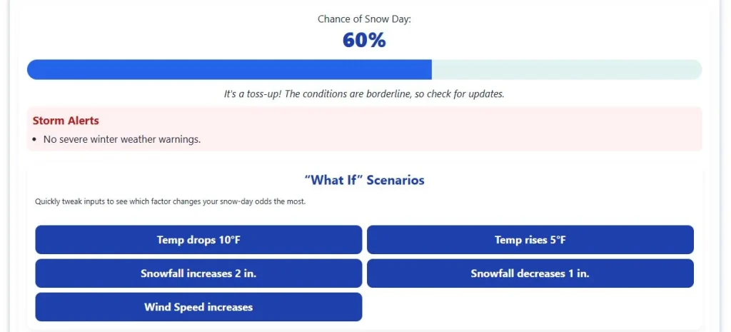
You can use the calculator when you want to explore a “what if” scenario, compare different weather conditions, or see how changes in the forecast could affect the likelihood of a snow day.

What Can You Calculate?
Enter the conditions you want to evaluate, including:
- Snowfall: How much snow is expected to accumulate.
- Ice accumulation: The amount of freezing rain or ice expected on roads and surfaces.
- Temperature: The expected temperature during the relevant school hours.
- Wind chill: How cold conditions may feel when wind is considered.
- Wind speed: Strong winds can increase blowing snow, drifting, and travel hazards.
- Storm timing: Whether the most disruptive weather occurs before or during the morning commute.
- District policy: Adjust the calculation for a school district that is more likely or less likely to close under borderline conditions.
The calculator combines these inputs to produce an estimated snow day probability.
When Should You Use the Snow Day Calculator?
The manual calculator is useful when you already know the weather conditions you want to test rather than simply asking for the current forecast.
For example, you can use it to compare:
- 2 inches versus 6 inches of snowfall
- Snow versus freezing rain
- A storm arriving overnight versus during the morning commute
- Moderate temperatures versus extreme cold
- A conservative district policy versus a more closure-prone policy
This makes the calculator useful for understanding how individual weather conditions can change the likelihood of a school closure.
Snow Day Calculator vs. Snow Day Predictor
The two tools answer slightly different questions.
- Snow Day Predictor: “Based on the forecast for my location, how likely is my school to close?”
- Snow Day Calculator: “Given these weather conditions, how likely would a school closure be?”
Use the Predictor when you want an automatic location-based estimate. Use the Calculator when you want to control the conditions and test your own scenario.
How Much Snow Does It Take to Get a Snow Day?
There is no single snowfall amount that guarantees a school closure. A district may cancel school after a few inches in one location but remain open after much more snow in another. What matters is how the expected accumulation affects roads, school bus routes, sidewalks, and the morning commute in that particular area.
Snowfall totals are therefore best understood as one part of a closure decision, rather than a universal cutoff.
Typical Snowfall Ranges and Snow Day Chances
As a general guide, the same amount of snow can produce different results depending on local winter conditions and district practices:
| Expected snowfall | What it may mean |
|---|---|
| 1-3 inches | Often manageable in areas accustomed to snow, but can cause closures where snow is uncommon or road treatment is limited. |
| 3-6 inches | Can create a meaningful risk of delays or closures, particularly when accumulation occurs overnight. |
| 6-12 inches | Often creates a high risk of school disruption, especially when roads cannot be cleared before the morning commute. |
| 12+ inches | Major travel disruption becomes increasingly likely, with closures common in many areas. |
These ranges are not official closure thresholds. Individual school districts make their own decisions based on local conditions and safety considerations.
Why the Same Amount of Snow Can Produce Different Results
A school district in a region that regularly handles winter storms may have extensive snow-removal equipment, treated roads, and established procedures for keeping bus routes operational. A district that rarely receives snow may face significant transportation problems with a much smaller accumulation.
For example, 3 inches of snow in a southern city can create more school-closure risk than 8 inches in a northern community if the southern area has less winter-weather infrastructure and less experience dealing with snow.
The timing of the snowfall can also change the outcome. Snow that accumulates several hours before the morning commute gives road crews more opportunity to clear routes than snow that is still falling when school buses are scheduled to operate.
Does More Snow Always Mean a Higher Chance of a Snow Day?
Generally, greater accumulation increases the potential for disruption, but snowfall depth alone does not determine the outcome.
A district may remain open after heavy but easily managed snowfall, while a smaller amount accompanied by hazardous road conditions can result in a closure. This is particularly important when snow is accompanied by freezing rain, sleet, strong winds, or extreme cold.
For that reason, there is no reliable rule such as “6 inches always means a snow day.” The actual closure decision depends on the conditions affecting your school and its transportation network.
What If There Is Very Little Snow?
A snow day does not require heavy snowfall.
Schools can close because of freezing rain, black ice, dangerous wind chill, poor visibility, or other winter hazards, even when the forecast contains little or no accumulating snow.
This is one reason looking only at the expected snowfall total can give you a misleading idea of whether school will be cancelled.
Can Freezing Rain or Ice Cause a Snow Day?
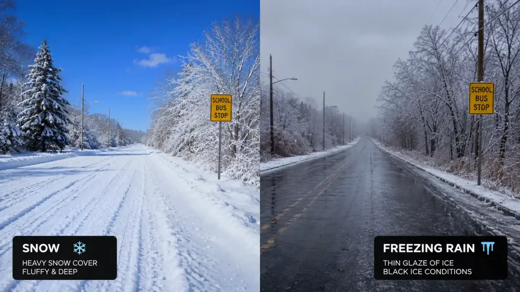
Yes. A school can close because of freezing rain or ice even when little or no snow is expected. In some situations, ice creates a greater transportation risk than a much larger amount of snow because it can make roads, bridges, sidewalks, parking areas, and school bus routes dangerously slippery.
Why Ice Can Be More Disruptive Than Snow
Snow can often be plowed, treated, and removed from major roads. Freezing rain is different because it freezes onto surfaces and can create a layer of ice that is difficult to remove quickly.
Even a relatively small amount of ice can affect:
- School bus routes: Icy roads make braking, turning, and stopping more difficult.
- Bridges and overpasses: These surfaces can freeze quickly and become hazardous before surrounding roads.
- Sidewalks and entrances: Ice can make walking to and around school unsafe.
- Parking areas: Frozen precipitation can create slippery surfaces for students, staff, and visitors.
- Morning travel: Conditions can be worst when freezing rain occurs shortly before buses and commuters are on the road.
Freezing Rain vs. Snow for School Closures
There is no universal rule that a particular amount of ice will close every school. The effect depends on temperature, the duration of the freezing rain, road treatment, and local conditions.
For example, a district may remain open during several inches of manageable snowfall but cancel school after a smaller ice event if roads and sidewalks cannot be made safe before the school day begins.
This is why snowfall totals alone are not a reliable measure of school-closure risk. A forecast with little snow can still represent a significant snow-day risk when freezing rain or ice is expected.
What Is an Ice Day?
An ice day is a school closure caused primarily by freezing rain, sleet, black ice, or other hazardous icy conditions rather than significant snowfall.
Some districts may announce an ice-related closure as a snow day, while others may describe it as a weather closure or emergency closure. The terminology varies, but the underlying reason is the same: conditions are considered unsafe for normal school operations.
If your forecast calls for freezing rain or significant icing, check your Snow Day Predictor for the overall school-closure probability rather than judging the risk from the expected snowfall total alone.
Can Extreme Cold Cause a Snow Day Without Snow?
Yes. Schools can close because of extreme cold even when there is no snow in the forecast. These closures are often called cold days and are most relevant in regions where winter temperatures and wind chills can reach dangerous levels.
The concern is not simply whether the temperature is below freezing. School officials may consider whether students can safely wait for buses, walk to school, travel on untreated roads, and remain outside during arrival and dismissal.
When Can Cold Weather Lead to a School Closure?
The risk of a cold-related closure increases when:
- Wind chill becomes dangerously low, making exposed skin lose heat much faster.
- Students must wait outside for buses in areas without adequate shelter.
- Extreme cold is expected during arrival or dismissal, when students are exposed to outdoor conditions.
- Vehicles and school transportation may be affected by severe cold.
- The district has a cold-weather closure policy or has historically cancelled school during similar conditions.
There is no universal temperature at which every school closes. A threshold that results in a closure in one district may not apply to another.
What Is a Cold Day?
A cold day is a school closure caused primarily by dangerously low temperatures or wind chill rather than snow or ice.
Cold-day decisions are particularly relevant in northern parts of the United States and Canada, where districts may have specific procedures for extreme winter temperatures. Other districts may consider the forecast alongside transportation conditions, student exposure, and local safety guidance.
Can You Have a Snow Day With No Snow?
Yes. The term snow day is commonly used for winter school closures even when snow is not the direct cause.
For example, a district could cancel school because of extreme wind chill, freezing rain, or dangerous ice while the forecast contains little or no accumulating snow. The important question is whether winter conditions make normal school transportation and student travel unsafe.
If your forecast is mainly showing extreme cold rather than snowfall, use the Snow Day Predictor to check the overall closure probability for your location.
Why Does Storm Timing Matter for School Closures?
The timing of a winter storm can change the likelihood of a school closure even when the total amount of snow or ice stays the same. School districts have to make sure roads, bus routes, sidewalks, and school entrances are reasonably safe when students are traveling to school.
A storm that is still developing during the morning commute creates a different situation from one that has already ended several hours earlier.
Overnight Snow and the Morning Commute
Snow that falls during the late evening or overnight can accumulate before road crews have enough time to clear it. If snowfall continues into the hours when school buses begin operating, crews may be trying to plow roads while buses are already traveling.
This can increase the chance of a school closure or delayed opening, particularly when accumulation is heavy or conditions are deteriorating.
Why the Morning Commute Is Important
School transportation creates a relatively narrow period when winter conditions matter most. Thousands of students may need to travel at approximately the same time, using school buses, cars, bicycles, or walking routes.
District officials may therefore consider:
- Whether primary and secondary roads can be cleared before buses begin their routes
- Whether snow or ice is still accumulating during the commute
- Whether visibility is sufficient for drivers
- Whether sidewalks and school entrances can be made safe
- Whether temperatures could cause treated roads to refreeze
- Whether conditions are expected to improve or deteriorate after the school day begins
What If the Storm Happens After School?
A storm occurring later in the day does not necessarily create the same closure risk for the following morning.
If precipitation begins after students have arrived at school, officials may instead consider whether conditions will become dangerous enough to require an early dismissal. If the storm continues into the evening and overnight, its impact on the following morning becomes more important.
The same storm can therefore lead to different decisions depending on when its most hazardous conditions occur.
Why Forecast Timing Can Change Your Snow Day Chances
Forecasts can change as a storm approaches. A storm initially expected to arrive after the morning commute may move earlier, or snowfall may continue longer than expected.
This is one reason a snow-day probability can change between an evening check and an early-morning check. The closer the forecast gets to the actual school commute, the clearer the expected timing and conditions generally become.
For a potential winter-weather event, checking your Snow Day Predictor again as the forecast updates can give you a more current estimate of the closure risk.
Why Do Some Schools Close While Nearby Schools Stay Open?
Two schools can experience the same winter storm and make different decisions about closing, delaying, or keeping school open. School closure decisions are made locally, so there is no single snowfall or temperature threshold that applies to every district.
The conditions around a school also matter. A district considers whether its transportation system, roads, and facilities can operate safely under the expected weather conditions.
School District Policies Are Different
Some districts are more cautious about winter weather and may cancel school when conditions are borderline. Others may continue operating unless conditions reach a higher level of disruption.
District officials may also have established procedures for:
- School closures
- Delayed openings
- Early dismissals
- Bus cancellations
- Extreme-cold closures
- Remote or virtual learning days
This means the same forecast can produce different decisions in different districts.
Roads and Transportation Can Change the Decision
School buses often travel much farther than most students do by car. A district may have routes covering rural roads, hills, bridges, or areas that take longer to clear.
Road conditions can therefore become a deciding factor even when the weather at the school itself does not look particularly severe.
A school located on well-maintained urban roads may have different transportation conditions from a school serving a large rural area, even when both receive the same amount of snow.
Local Conditions Can Be Different Even Nearby
Winter weather can vary over relatively short distances. Snowfall totals, ice accumulation, visibility, temperature, and road conditions may not be identical across neighboring communities.
Lake-effect snow is one example where one location can receive significantly more snow than another location only a short distance away.
Because school closure decisions depend on local conditions, a closure announcement from a nearby district should not automatically be treated as evidence that your own school will close.
Why Your District’s Decision Matters Most
The most useful comparison is not whether another school has closed. It is whether the conditions affecting your school and district are likely to interfere with normal operations.
The Snow Day Predictor provides an estimate based on the weather forecast for your location, but the final decision always belongs to your school district.
For confirmation, check your district’s official website, notification system, or other official communication channel when a closure or delay is being considered.
Snow Day vs. 2-Hour Delay vs. Early Dismissal
A winter weather forecast does not always result in a full school closure. Depending on the expected conditions and when they occur, a school district may cancel classes, delay the start of school, dismiss students early, or keep the normal schedule.
Snow Day: School Is Closed
A snow day means students do not attend school in person because the district determines that conditions make normal operations unsafe or impractical.
A full closure is more likely when winter weather is expected to interfere with transportation for a significant part of the school morning or when conditions are unlikely to improve enough for a safe opening.
Some districts may replace an in-person snow day with remote instruction, depending on their local policy.
2-Hour Delay: School Starts Later
A 2-hour delay or delayed opening allows additional time for road crews to clear routes and for hazardous conditions to improve. A district may choose a delay when:
- Roads are expected to become safer later in the morning.
- Snow or ice is ending before normal school start time.
- A full closure is not considered necessary.
- Additional time is needed to prepare bus routes, parking areas, and school entrances.
A delay can therefore represent a middle ground between keeping the normal schedule and cancelling school completely.
Early Dismissal: School Closes During the Day
An early dismissal occurs when school begins normally but worsening weather makes it necessary to send students home before the regular end of the school day.
This can happen when a storm arrives or intensifies after students have already arrived, particularly when afternoon travel conditions are expected to deteriorate.
Early dismissal also creates an additional transportation challenge because districts must coordinate buses and other transportation while weather conditions are changing.
Virtual or Remote Learning Day
Some school districts use a virtual learning day instead of cancelling instruction completely. Students remain at home and complete schoolwork remotely according to the district’s procedures.
Whether a district uses remote instruction depends entirely on its own policies and available technology. A high probability of a weather-related disruption therefore does not always mean students will have a traditional day off.
Which Outcome Is Most Likely?
The final decision depends on the district’s assessment of conditions and its operating policies. In general:
| Situation | Possible district response |
|---|---|
| Roads and weather are manageable | Normal school day |
| Conditions may improve after the usual start time | 2-hour delay |
| Conditions are unsafe for most of the school day | Snow day / school closure |
| Weather is expected to worsen after school starts | Early dismissal |
| District has a remote-learning policy | Virtual learning day |
A snow-day probability should therefore be interpreted as an indication of weather-related school disruption, not as a guarantee that the district will choose one specific response.
Always check your school’s official announcement for the final decision.
What Does Your Snow Day Probability Percentage Mean?
The Snow Day Predictor gives you a probability percentage that represents how likely the current weather conditions are to result in a school closure. It is an estimate, not a guarantee, because the final decision is made by your school district.
A higher percentage means the evaluated conditions point toward a greater likelihood of school disruption. A lower percentage means the conditions are less likely to result in a closure.
Snow Day Probability Guide
| Probability | What it means |
|---|---|
| 0%-29% | Low chance: A normal school day is more likely, although conditions can still change. |
| 30%–59% | Moderate chance: A delay, closure, or other weather-related change is possible. |
| 60%-79% | High chance: A school closure becomes increasingly likely, but an official decision is still needed. |
| 80%-100% | Very high chance: Conditions strongly favor a closure, although the district makes the final decision. |
These ranges are a practical way to understand the prediction. They are not official closure thresholds used by every school district.
Does a 70% Snow Day Chance Mean School Will Close?
No. A 70% snow day probability does not mean there is a 70% guarantee that school will close.
It means the weather conditions being evaluated indicate a relatively high likelihood of school disruption. The actual decision can still depend on local road conditions, transportation, school district policies, and changes in the forecast.
Likewise, a low probability does not make a closure impossible.
Snow Day Probability vs. Chance of Snow
Snow-day probability and precipitation probability are not the same measurement.
For example, a weather forecast could show a 40% chance of snow, while the Snow Day Predictor could produce a higher or lower school-closure probability.
The precipitation percentage describes the likelihood of precipitation in the forecast. The snow day probability considers whether the resulting conditions could lead to a school closure.
Why Can Your Snow Day Probability Change?
Your prediction can change when the underlying forecast changes. For example, the probability may increase if:
- Expected snowfall becomes higher.
- Freezing rain or ice becomes more likely.
- The forecast shifts toward more disruptive conditions.
- Temperatures become colder.
- The expected weather changes in a way that could affect school transportation.
The probability can also decrease when the forecast becomes less disruptive.
For the most current estimate, you can check the Snow Day Predictor again as the forecast develops. Once your school district announces its official schedule, that announcement should always take priority over the predicted probability.
When Should You Check the Snow Day Predictor?
The best time to use a Snow Day Predictor is when you want to know how the latest forecast could affect school operations in your area. Because winter forecasts can change as a storm develops, checking more than once can give you a better picture.
Check the Night Before
The evening before a potential winter storm is a useful time to check your prediction. You can see whether the current forecast points toward a low, moderate, high, or very high chance of school closure. This is especially useful when:
- Snow or ice is expected overnight
- A winter storm warning or advisory is in effect
- Temperatures are expected to drop significantly
- The forecast has recently changed
- You need to plan for the next morning
Check Again in the Morning
If conditions are changing quickly, check the Snow Day Predictor again before leaving for school. The latest forecast may differ from what was expected the previous evening.
However, the predictor should not replace your school district’s official announcement. A district may announce a school closure, delay, early dismissal, or normal schedule based on conditions that are not fully represented by a general forecast.
Use the Predictor for the Estimate, Your School for the Decision
Think of the process this way:
Snow Day Predictor → estimates the likelihood <–> School district → makes the official decision
If your district has already announced a closure or delay, follow that announcement regardless of the prediction percentage.
For the most useful result, check the predictor when you are making your plans and compare it with your district’s latest official communication.
How Accurate Is the Snow Day Predictor?
The Snow Day Predictor is designed to give you a useful estimate of school closure likelihood, not a guaranteed answer. Its result depends on the weather forecast available for your location and the conditions that may affect whether schools can operate normally.
Winter weather can change quickly, so the prediction can change when the underlying forecast changes.
Why Can a Snow Day Prediction Change?
The predicted probability may change when the forecast changes. For example, expected snowfall may increase or decrease, precipitation may change from snow to freezing rain, temperatures may shift, or the expected conditions may become more or less disruptive.
The predictor uses the available forecast information at the time you check it, so a new forecast can produce a different result.
Why Isn’t a High Probability a Guarantee?
Even a high snow day probability cannot guarantee that your school will close.
School districts make their own decisions based on local circumstances. They may consider information about roads, school bus routes, snow removal, school property, and other conditions that may not be fully represented in a general weather forecast.
A district could therefore remain open when the predictor shows a high probability, or close when the predicted probability is lower than expected.
How Should You Use the Prediction?
Use the Snow Day Predictor as a planning and information tool. It can help you understand what the current forecast suggests about the likelihood of a school closure.
For the most current estimate, you can check the predictor again when the forecast changes. But when your school district publishes an official closure, delay, or other schedule announcement, that official decision should always take priority over the prediction.
In simple terms:
The Snow Day Predictor estimates the likelihood. Your school district makes the final decision.
What Information Does the Snow Day Predictor Use?
The Snow Day Predictor uses the available weather forecast for your selected location to estimate the likelihood of a school closure. Rather than relying on a single snowfall total, it looks at several weather conditions together.
The information used for the prediction can include:
- Expected snowfall and other precipitation
- Precipitation type, including snow, sleet, and freezing rain
- Temperature
- Wind chill and wind conditions
- Storm timing
- Other relevant winter-weather conditions
- District policy
Your Location Affects the Prediction
Weather conditions can vary between nearby areas, so the predictor uses the location you provide when generating the estimate.
You can enter a city, ZIP code, postal code, or coordinates, or use your current location when the option is available.
This makes the prediction location-specific rather than applying the same weather conditions to every school.
District Policy Also Matters
Weather conditions alone do not determine whether a school closes. Different school districts may respond differently to similar winter weather.
The predictor includes a district policy setting so you can indicate whether the district is more conservative, neutral, or more likely to remain open under borderline conditions.
The result combines the available forecast information with the selected policy to provide an estimated snow day probability for the conditions being evaluated.
When Do School Districts Announce Snow Day Decisions?
School districts do not all announce snow days at the same time. The timing depends on the expected weather, local conditions, transportation needs, and the district’s own procedures.
When a winter storm is expected to affect the next school day, districts may announce a closure, delayed opening, early dismissal, or normal schedule once they have enough information to make a decision.
Why Decisions Are Often Made Before School Starts
District officials need time to coordinate transportation, notify families and staff, and prepare schools for the expected conditions. A decision may therefore be announced before students are scheduled to leave for school.
The exact timing can vary, especially when the forecast is uncertain or conditions are changing.
What If the Forecast Changes Overnight?
A district may continue evaluating conditions if the weather develops differently from the forecast. Snowfall, freezing rain, road conditions, and temperatures can change the situation between the evening and morning.
This is why an earlier prediction or announcement should not be treated as a substitute for the district’s latest communication.
Where Should You Check for the Official Decision?
For the final answer, check your school’s or district’s official communication channels. These may include:
- The school district’s official website
- Parent or student notification systems
- Official email or text alerts
- The district’s verified social media accounts
- Local school communication platforms
The Snow Day Predictor can help you estimate the likelihood of a closure from the available forecast, but only your school district can confirm whether classes are cancelled, delayed, or continuing normally.
What Is a Virtual Snow Day?
A virtual snow day is a school day when students stay home because of winter weather but continue learning remotely instead of having the day completely off.
Whether a district uses virtual learning during severe winter weather depends on its own policies, technology, and instructional requirements.
How Does a Virtual Snow Day Work?
On a virtual snow day, students may be asked to complete lessons, assignments, or other activities from home. Some schools may provide live online classes, while others may use online platforms for independent work.
The exact format varies from one school district to another.
Is a Virtual Snow Day the Same as a Traditional Snow Day?
No. A traditional snow day generally means in-person classes are cancelled for the day. A virtual snow day allows instruction to continue remotely.
For students and parents, this distinction matters because a school closure announcement does not necessarily mean that all schoolwork is cancelled.
Does the Snow Day Predictor Tell You If School Will Go Virtual?
The Snow Day Predictor estimates the likelihood of a weather-related school disruption based on the available conditions and selected district policy. It does not determine whether your district will use remote learning.
If your school announces a closure, delay, or virtual learning day, follow the district’s official instructions for that specific day.
Who Can Use a Snow Day Calculator?
A Snow Day Calculator can be useful for anyone who wants to understand how different winter weather conditions could affect the likelihood of a school closure.
Students
Students can use the calculator to explore different weather scenarios and get an idea of how conditions such as snowfall, ice, temperature, and wind chill could affect the chance of a snow day.
Parents and Families
Parents can use the calculator when planning for a potential winter storm. Comparing different weather scenarios can help families understand why a forecast may create a higher or lower risk of school disruption.
Teachers and School Staff
Teachers and school staff can also use a snow day calculator to explore how changing weather conditions may affect the likelihood of delays or closures.
Anyone Exploring a Weather Scenario
You don’t need to wait for an actual snowstorm to use the calculator. Because it allows you to enter your own conditions, you can use it to answer “what if?” questions, for example, what happens to the estimated closure probability when snowfall, ice, temperature, or storm conditions change.
For a current location-based estimate, use the Snow Day Predictor. For a scenario where you want to control the weather inputs yourself, use the Snow Day Calculator.
Frequently Asked Questions
About Snow-Day.Net
Snow-Day.Net helps students, parents, and families understand the potential impact of winter weather on school schedules. The website provides two different tools for checking snow day chances:
- Snow Day Predictor: Get a location-based estimate using the available weather forecast for your area.
- Snow Day Calculator: Enter your own weather conditions to explore different snow day scenarios.
Both tools are designed to make winter-weather information easier to understand. The results are estimates and should not be treated as official school closure announcements.
For the final decision, always check your school district’s official communication for information about closures, delays, early dismissals, or remote learning.